The 2013 Tour of Honor ends on 31 October 2013, so I had just a few days left to visit memorials and do a little sightseeing on a beautiful fall weekend. I crafted a nice route that would allow me to complete the four New Jersey memorials (Connie and I had previously visited the memorial in Camden, NJ) and visit the memorial in Manhattan. While I was at it, I wanted to do a little geocaching along the way to add a few more counties to the count.
This was my planned route for Saturday, 26 October 2013:

With my propensity for dawdling, I wanted to get on the road and head more-or-less straight for my first planned stop in Bayonne, New Jersey. I stopped for a brief lunch at Perryville, Maryland, then got back on I-95.

My first [planned] stop of the day was the To the Struggle Against World Terrorism monument in Bayonne, NJ.

I took a somewhat circuitous route to and from the monument so I could take in the local scenery. The Military Ocean Terminal has been repurposed, somewhat. There’s a cruise ship terminal there now, along with a ship repair / graving dock facility (you can see the graving dock on the southern-most of the two long piers in the map, below).

These two gigantic piers are constructed of fill, and stretch quite a way out into the Upper New York Bay.


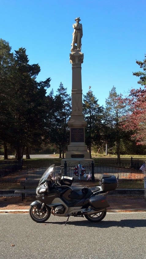
My second planned stop of the trip was the 9/11 Memorial Preview Site. There was a little traffic on the approach to the Holland Tunnel – I had a nice chat with some motorcycle (and cigar) aficionados while waiting. My track is ratty because of the tunnel and multi-path in Manhattan. The trip to the site was uneventful, if not a bit slow because of Saturday traffic.

I was in a bit of a hurry to get the photograph, then get back to my bike, so they’re not the best photographs I’ve taken this year.


I had great parking while at the preview site. When I pulled up, I read the sign as saying that spot was reserved, but it was only reserved during the work week. So, I was all set. At the moment I took this picture, all the tourists who had been milling about at the site had moved on.


From here, I wanted to head uptown to grab a few geocaches. My planned route uptown was a mess, so I chose to ride north through Chinatown and the Bowery, which is always colorful.
My next stop was the virtual geocache at the Ralph Kramden statue located at the Port Authority Bus Terminal (the traffic was fierce, so I didn’t stop for a photograph).
From there, I wanted to head north to Central Park to snag a few more geocaches, but the roads in the lower part of Central Park were closed that weekend because of the New York Marathon. I bailed on the rest of Manhattan, and headed for some geocaches in Queens. My track to and across Queens was predictably interesting. I did see a R1200GS while crossing the bridge into Queens, so that was nice.

I had planned to do a little geocaching at Flushing Meadows – Corona Park I got one cache, then decided to press on.
The light was growing dim when I took this picture, but the graininess of the photograph helps hide some of the more significant flaws of these three observation towers at the New York State Pavilion (which are in serious need of a little needle-gunning, primer, and a good paint system).

I’d left a little later in the day than originally planned, so I wound up leaving Queens somewhat later than planned. I decided to head directly for The Rockaways to snag a couple of geocaches in Queens County.

The virtual geocache I wanted to find at Fort Tilden was closed, so I headed west to Coney Island (Defending the Honor of American Popular Culture?!). I’d hoped to find a geocache while there, but I just couldn’t find it.

I did, however, have time to stop for a couple of Nathan’s Famous Hot Dogs, straight from the source. It was a beautiful night to eat outside…I only had one panhandler come by to check on the spare change supply.

I wanted to ride to the Brooklyn side of the Brooklyn Bridge to do a little geocaching and to get some photographs of the bridge. My initial route had me riding over the bridge both ways to get a cache on the southern end of Manhattan, but I was always willing to drop that if I was running low on daylight.
My traffic-enabled zūmo 665 determined that the Brooklyn Bridge was closed, so all of my subsequent routing went out the window. I knew basically where I wanted to go, so I just headed north to a pair of geocaches adjacent to the Brooklyn Navy Yard.

I got to see impromptu street racing in Brooklyn, and arrived at the scene of a pedestrian-vehicle collision immediately before the emergency vehicles arrived. Wow. That ride north through Brooklyn was awesome.
There’s a geocache across the street from Steiner Studios (which is located at the former Brooklyn Navy Yard). There’s another geocache outside the gate of Quarters A at the Brooklyn Navy Yard. I was able to grab both.

I’ve never before been to the Brooklyn Navy Yard (or any of the nearby sights), so seeing that area was a real treat. The neighborhoods of Vinegar Hill, Dumbo, and Brooklyn Heights are definitely worth a return trip.
I had wanted to see the Brooklyn Bridge at night, so I found a nice spot on John Street in Brooklyn for a photograph.

It was past 2200, so it was time to head back to NJ to find a place to stay for the night. Before getting back on I-278, I wanted to do a little more sightseeing. I took this photograph at Brooklyn Bridge Park Pier 6 along the East River.

I was nearly across Staten Island, when I decided that I just HAD to stop for a geocache in Richmond County, NY. So, I did.

I didn’t have a particular location to stay, so I figured I would get another couple of geocaches in New Jersey, then figure it out. It was a beautiful evening, and the traffic was light, so I just enjoyed the ride.

This is the Quick Stop Groceries in Leonardo, New Jersey, featured in the movie Clerks (the store location is also a virtual geocache).

I also visited a spring that Henry Hudson used to re-provision his ships, but it was far too dark to produce a good picture.
I found a La Quinta hotel in West Long Branch, NJ to bed down for the night.
I got going in the morning, with both geocaches and Tour of Honor memorials in my sights.
The first stop was a marker for Ye Olde Robbins Burial Place (which marks the general location of Deborah Lincoln’s grave).


My next stop was the Carranza Memorial in Tabernacle Township, NJ. What a place to visit (especially on a sport-touring motorcycle)!

Next, was a Revolutionary War memorial near Port Republic, NJ.
Next up: Brigantine, NJ.

This monument is located outside the Atlantic County [NJ] Library in Brigantine, NJ. It’s a virtual geocache.

My next stop was the New Jersey Korean War Memorial in Atlantic City for another virtual geocache.


My last stop in Atlantic City was the Greek Temple Monument (the World War I Memorial), where I was to take a photograph of Liberty in Distress, and my Tour of Honor flag. This stop was also good for a Iron Butt Photo Tag photograph.

I was running out of time to catch the last ferry from Cape May to Lewes, so I decided to head directly for the ferry terminal.

I got to the terminal with enough time to spare that I could ride back to McDonalds for a quick bite.
There was a brief wait back at the ferry terminal, long enough for a few pictures.

I was the first to board, so got a nice spot at the front of the ship.

The sun was setting just as the crew was making preparations for getting underway.

And now we’re underway!

It’s about an hour and a half to Delaware…just enough time to sit down and do a little reading. I had so much cold weather gear on that I spent much of the trip on the weather decks just to keep comfortable.
My only stop in Delaware was the Rehoboth Veterans Memorial.

The ride home was uneventful…I made it back to the barn about 2230. This was an awesome trip.
