Showing posts with label Ride Report. Show all posts

Monday, February 20, 2017

19 February 2017 Ride Report

I got a very late start on Sunday -- the weather was decent, the list of undone chores was manageable, and there was a [short] list of nearby Big Money Rally bonuses to knock out. The four local "stadiums" on the list -- Nationals Park, Verizon Center, FedEx Field, and the Prince George's Stadium were worth just over 12 points total -- plus several "campground" bonuses promised a good point total day.


Nationals Park
Verizon Center
Lincoln Park Kitchen & Wine, Lincoln Park, Washington, DC


FedEx Field, Landover, MD

Prince George's Stadium, Bowie, MD


With such a late start (almost 1400), I was up against the clock to get as many bonuses as I could before the light gave out. The need to have the motorcycle in the shot greatly limits my night bonus hunting ability. I shed a few western bonuses, but still managed a great afternoon (and early evening) of point gathering.


Tin Cup Products, Falls Church, VA

12 February 2017 Ride Report

The weather forecast promised much, so Donna and I headed out for a Sunday ride to Lynchburg and other points south. I'd been frustrated, on the 21 January 2017 ride, with missing both the Manassas train depot and the Lynchburg stadium bonuses. So, it was time to redeem myself and take Donna on a nice winter ride.

The temperature was in the mid-40 degrees F when we left -- the forecast for Lynchburg was in the upper-70's by mid-day. 

We headed west through Manassas (and got credit for that train depot), then south on U.S. 29, grabbing bonuses along the way. We successfully snagged the Lynchburg stadium bonus (where I've now been several times -- the Team Strange 30 ball park bonus set caused me to stop by there, as well as many other locations across the country). By the time we reached Lynchburg, the temperatures were above 80 -- 83 degrees F was the highest temperature I saw all day. Not bad for February!

We had a great time between Lynchburg and Richmond, then headed home when it got dark.

Great ride -- a nice test of heated gear, with a little early spring weather thrown in for good measure!

Sunday, June 8, 2014

Sunday, 8 June 2014 Ride Report

Time for another ride!

There were a few nearby bonus locations that needed to be finished, so they constituted today’s ride. A Grant County (WV) sign (for the Team Strange Airheads Presidential Grand Tour), the 10th Mountain Division memorial at Seneca Rocks (Tour of Honor), and the Edinburg, VA Post Office (for the Team Strange 30th Anniversary Grand Tour).

I’d wanted to take Connie along some of Old WV Route 55, so that was in the mix, also.

image

The weather was perfect…it was in the mid-70’s when we left, and didn’t get above about 85 all day. The temperature dipped to the mid-60’s as we rode through areas affected by recent thunderstorm activity. We were rained on a bit in Petersburg, VA but a couple of stops under gas station awnings ensured we missed the worst of the downpours.

U.S. Route 48 is slowly straightening the route that old WV Route 55 still follows. The old road is quite twisty, so it’s a lot of fun on a motorcycle. Since we weren’t in any hurry to get to where we were going, it was a wonderful day to explore the old road.

We got fuel at the new Sheetz in Moorefield, then headed south to Petersburg. After a bit of a rain delay, we reached the Grant County (named for U.S. Grant) line, and got the needed photograph.

Our next stop was the Front Porch Restaurant at Seneca Rocks. We try to stop there every time we’re through the area. We had a nice, and somewhat extensive, discussion with the motorcyclists at the next table.

After lunch, we headed over to the 10th Mountain Division memorial at the Seneca Rocks Discovery Center. It took a couple of tries to find the best access (with motorcycle parking available), but find it we did.

From Seneca Rocks, we headed south and east on U.S. 33 until nearly to Harrisonburg. We’d been on I-81 A LOT, so I wanted to find some back roads to take us home. We took routes 613 and 42 through some wonderful farm country, and along some amazing ridge views.

We got the needed Edinburg, VA Post Office photograph, then continued north through Woodstock and Toms Brook. We picked up I-66 where it intersects U.S. 340 (and where we got something chilly to drink), and headed for the barn.

Another great ride and a great day!

Sunday, June 1, 2014

Sunday, 1 June 2014 Ride Report

I picked up the bike from Bob’s BMW on Saturday, and needed to get out for a shakedown run. Connie mentioned that she wanted to return to a place we both enjoyed in Washington, Virginia, so off we went!

There’s a tradition in the long-distance riding community called a Ride to Eat. Usually, these RTE events involve many hundreds of miles…we didn’t have that much time, so a short ride around Virginia was in order.

image

I planned to get us to Stonyman Gourmet Farmer at lunchtime, so we took a somewhat circuitous route. We headed west along I-66, and turned south to explore Fort Valley Road. It’s beautiful.

image

So, we cruised south until we got to U.S. 211, then headed east for lunch. U.S. 211 is a great road, fully of “twisties”.

We had a great lunch at Stonyman Gourmet Farmer – BLT sandwiches with salad, and soda. The temperature was marvelous, so we sat outside in their garden courtyard, and enjoyed out meal (and the birds).

From Washington, we headed north to ride a stretch of Skyline Drive through Shenandoah National Park. We were “warned” we might see bear, but alas, no bears were in sight. We did have a great ride, though.

We headed home via Stanardsville and Ruckersville, familiar territory for our rides.

All that, and we got back at a decent hour!

Saturday, February 22, 2014

Ride report: Saturday, 22 February 2014

The weather so far this year has been pretty chilly (more than a few days in single digits). I’ve only been out for a ride once, and that was in January. Connie hasn’t been riding since last year. So, when it became obvious that we were going to have decent weather over the weekend, I got about planning a couple of rides (one for Saturday, and another for Sunday if I could trade riding for chores). We’re engaged in the Big Money Rally 2014, so I selected from that big list of bonus locations to plan Saturday’s ride.

image

The planned route is in red; the dark cyan is the track.

We got started early (well, earlier than I often get going on weekend rides), and headed for the William Preston Lane, Jr. Memorial Bridge, just east of Annapolis, Maryland. There was a big wreck on the outer loop of the Capital Beltway (surprise!), so we did a little detour to get onto U.S. 50 East.

Clear days are an especially nice treat while on the bridge, because it’s the highest point around. I like stealing glances of the ships at anchor, just south of the span. The traffic on this chilly Saturday morning was light; fast forward just a few months, and the weekend traffic can be daunting.

The major theme of this ride was libraries – our mission was to find specific libraries, then get a smartphone photograph of a library sign (free standing or on the library itself), our rally “flag”, and the bike. It’s great when Connie is along because, in addition to being wonderful company, the flag is in the right place in the photograph.

We had a late breakfast at Southern Grill in Seaford, Delaware, a little mom-and-pop diner.

In addition to taking a lot of photographs of libraries, we stopped to do one virtual geocache.

We completed the ride by heading south on I-95, all the way to Virginia.

Sunday, October 27, 2013

Late-October 2013 ride

Saturday, 26 October 2013

Got on the road about 1000. Headed right for Bayonne, NJ. Stopped for lunch at the outlet store place. Bayonne was amazing...you really need to know where you're going to find that memorial. Great views.

Got to Manhattan just fine. Took the Holland Tunnel. Lots of GPS bounce, but I knew where i was going. Great parking. Lots of people in the visitors center. Got inside and took the picture, then got back to the bike.

Wanted to go uptown. Nice ride...lots of jaywalkers. Traffic wasn't too bad. Lots of double-parking. Central Park South was a mess. Road into Central Park was closed because of the upcoming marathon. Decided to go to Queens. Saw a GS. Road to Flushing Meadows was interesting. Flushing Meadows has faded. Headed south to Far Rockaway, the to Coney Island. Went north so I could get some pictures of the Brooklyn Bridge and the Manhattan skyline. Saw the big house at the Brooklyn Navy Yard, and Steiner's Studio. Brooklyn Bridge going into Manhaytan was closed. Where does Flatbush Avenue go? Saw a guy who'd been hit, lying in the street with a bunch of guys helping him. Ambulance hadn't gotten there yet. Before that, saw two vehicles driving recklessly.

Rode out over Verrazano-Narrows Bridge. Stopped to snag a geocache in Richmond County, the headed into NJ. Got a couple of geocaches there. National Park was closed for the day, so i continued south. Stayed at a La Quinta.

Sunday, 27 October 2013

Great sleep. So-so breakfast. Got on the road, heading south. Had a couple of virtual caches to get, and two stops on the 2013 Tour of Honor. Knew that the last ferry to Lewes sails at 1800, so headed for the ferry terminal. Got there with plenty of margin. Got dinner, took a bunch of pictures, and enjoyed the ride.

Sunday, July 14, 2013

14 July 2013 Ride Report

I’m trying to get out on a long ride at least once a month, and with Butt Lite 7 (VII? Se7en? IIIIIII?) on the horizon for next summer, there’s some serious training to be done.

This weekend’s ride was also designed to get into cooler temperatures, by riding into the hills of West Virginia.

We headed west, out I-66 to US-48, then into WV. We had a very nice late breakfast / early lunch at Sunset Restaurant in Moorefield. There was a group of riders there, enjoying a meal. There’s a very large chicken sculpture right across the road from the restaurant…we didn’t stop for a picture (this time).

I wanted to take a side road, skirting south of Petersburg to get a little different scenery. It had been a long time since I’d been on that road, and it was nice to see not much has changed.

We picked up U.S. 220 just south of Upper Tract, WV. Just shy of Franklin, we turned west onto U.S. 33 – this is a great motorcycle road. We rode south on WV 28 until we got to U.S. 250, then we turned east through Monterey, VA. I’d like to come back to explore Monterey one of these weekends.

We stopped for some ice cream and soda at the Tastee Freez in Churchville. There were other bikes there, as well – usually a good sign.

We picked up I-81 at Staunton, and rode north to New Market, where we took U.S. 211 east to Warrenton. As much as I enjoy U.S. 211, the route along U.S. 33 and U.S. 250 is really better.

From Warrenton, we picked up U.S. 29, and wound up in a big traffic jam in Gainesvillle. Ugh. We took U.S. 15 north to get around that, and headed back on I-66 all the way home.

It was a great ride!

image

Elevation profile:

image

Friday, May 10, 2013

Ride Report -- 10 May 2013

The Big Money Rally is rapidly coming to an end, and I needed to scrounge up 28 points to be a finisher this year. I planned a route that would take me south, somewhat west, then north again. That route would net 19 of the 28 points needed, which was very good. I ended up having to make a trip over to Joint Base Andrews, however, that soaked up two of the hours needed for that ride.

I deleted a four-point trip to Momma Rosa’s in Gretna, Virginia to get some time back. That left me with 15 points for the day, which wasn’t too bad.

As you can see, I got a much later start on the day than I should have to get this much riding done. Also note that it was 63 deg F…it would get to 90 deg F (or warmer) during the ride. Wow. Summer’s here (already).

image

The ride south was all slab, but I this was a rally-like run, so I needed to get south to start collecting bonuses.

The weather was really good, and since it was a Friday morning, the traffic was heavy but moving very fast. I tucked myself in amongst the I-95 crowd, and moved along.

Today’s ride was to be a LOT of rural road riding after the slab south. I was destined to ride through a lot of older, rural settlements.

My first stop was to Grandpa’s Kitchen in Littleton, NC. Littleton is an interesting place…one of the thousands of interesting places I get to see on the bike.

Note the flying pig on the sidewalk. For such a small town, there was a lot of traffic on the main drag.

Next stop: Boydton, Virginia (which, incidentally, is the home of a Microsoft Data Center). The coordinates I had loaded for the Boydton Volunteer Fire Department were off by quite a bit, so I did a little riding around Boydton to find the right location.

From  Boydton, I headed north to Drakes Branch, Virginia.

From Drakes Branch, I continued north to Meherrin, Virginia, birthplace of Roy Clark.

Then, on to Burkeville, Virginia. A local resident came over to see the bike, and to chat a bit. A drawback of a full-face helmet is that small talk is tough.

Here’s the Dillwyn, Virginia Fire Company’s building:

My last stop of the day was James Madison’s Montpelier.

From Orange, it’s a short ride home.

Saturday, April 27, 2013

Saturday, 27 April 2013

Connie and I needed to do a little practice riding in advance of this year’s Mason Dixon 20-20, so we planned a nice Saturday ride. It was a great excuse to knock out a few more Big Money Rally bonus locations, along with a few Tour of Honor memorials.
We got a nice morning start, heading up I-295 / MD-295 through Maryland and the District of Columbia under a cloud-less sky. Road conditions were okay (I travel part of that route every workday, so I know where the worst potholes are located), and traffic was light for a Saturday morning.
image
Our first stop was the Caesar Rodney statue in Wilmington, Delaware, for a Tour of Honor memorial. We’ll be back to find his grave in Delaware for a future bonus location.

image
After Wilmington, we had a nice ride up I-95, to two stops in the Philadelphia, PA and Camden, NJ area.
image
Our stop in Philadelphia was to the Korean War Memorial.

The stop in Camden, NJ was to the Merchant Marine Memorial. The memorial is very close to the berth of USS New Jersey (BB 62), on the Camden waterfront.

Connie wanted to see a bit of Camden, so we took a somewhat circuitous route back to the bridge. We didn’t get to see ALL of the sights, but we saw quite a few.
image
From Camden, we headed west across the bridge, then west to our next stop – West Chester, Pennsylvania.
image
We found a bit of really bad traffic on the way to our next stop, so we took a bit of a detour north – up through an area that was known as Rittenhouse during the early days of Philadelphia. This is one of those locations that’s worth a return trip.
Our next stop was to a virtual geocache in West Chester, PA. West Chester was a happenin’ place while we were there – lots and lots of people on the streets, with quite a few sidewalk restaurants and a general welcoming feel. This is another place to which we want to return.

We next visited the Haym Solomon Memorial Park in Chester County, Pennsylvania, the location of Jim Croce’s grave.
image

We continued north to the rugged highlands of the Gettysburg-Newark Lowland Section.
image
There, we were destined to find the Spring Mountain Ski Area closed, regrettably, for the season. I thought the Tiki Bar was a nice touch. We couldn’t afford the time needed to completely scout the place, because we had to get back on the road.

Our original plan had us heading northwest to another ski area, but we were running out of daytime, so we headed for our last scheduled stop – an eatery in Pottstown, Pennsylvania. In yet another twist of fate, we arrived too late to visit “The Very Best Hot Dogs, Hamburgers, Steaks in Pottstown since 1921”. Next time, as “they” say.

Aside from a stop at a Jimmy John’s for a sandwich, it was time to make tracks for home. What a great ride!
image

Monday, October 8, 2012

2012 Void Rally Ride Report

Wow…another great Void Rally is in the bag. The Void is essentially the end of the rallying season here on the east coast. There are one or two short local rallies after the Void this year, but the Void is the last of the 24-hour rallies on this coast.
image

Preparation.

The rally book for the Allentown starters came out on Tuesday, 2 October 2012. That gave me Tuesday evening and Wednesday evening to think about the routing options, before heading northeast to Allentown on Thursday. I worked up a couple of what I thought were good options, and slept on it to see if I got any more insight.

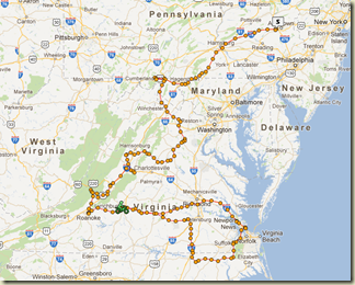
One of the themes for this year’s Void (there’s a theme every year) was SQRT(49), so the bonus location values were all a multiple of 7. I fixated on a bonus location at Fort Monroe, VA – this was a bonus location that I didn’t select during Butt Lite 6IX, and I got it into my head that I just had to go this time. To add to the challenge, the Fort Monroe bonus didn’t open until 1030, and the route between Fort Monroe and Lynchburg meant that I had to leave moments after 1030 to make it to the finish before penalties started.

With a couple of options plotted out, I was ready to head to Allentown. Connie was originally to ride with me, but she wound up on the injured list, so I rode this one solo. Bummer.

I got my usual late start out of Northern Virginia, so I wound up arriving in Allentown after midnight.

Allentown.

I stayed at the Hampton Inn in Allentown on Thursday night. I had called ahead to make sure they (a) had an Allentown address on their receipt, and (b) could give me a checkout time on the checkout receipt. I was very happy about getting this critical planning element out of the way so early.

The hotel certainly came through on (a), but I didn’t find out until 0850 (the opening of the start time) that the counter person couldn’t manage to get a printed time on the checkout receipt. Ugh. Well, I was off to find a place that could generate a proper receipt before the 0910 deadline. I stopped at a Sunoco station (that other riders had tried), only to find that the clock on the register was over one hour off. Amazing. So, I tried a CVS – didn’t have an Allentown address. Finally, I located a Rite Aid that was in the right place, and had the correct time on their receipt. With a couple of minutes left until I became a DNS (Did Not Start – riders that weren’t officially on the road by 0910 were out of the event), I had my receipt in hand, and the required text was sent to the rally staff. The lesson here was to skip the reliance on the hotel, and scout out the big box drugstores in the area.

The Ride.

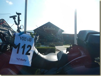
My first bonus location was the Cabela’s store in Hamburg, PA. I had visited this store during its grand opening several years ago, and it was nice to stop by again, even if only for three minutes. The store is a spectacle of outdoor gear and activities – I heartily recommend it as a stop.

There’s a nice sculpture of a canoe out front, and my assignment was to get a photograph of my flag and that sculpture. As it often is, my bike was a perfect rally flag holder.
DSCN0415

From Hamburg, I traveled southwest to visit the highway marker for the Tapeworm Railroad. As you can see in the photograph, there were several of us on this route.

DSCN0417

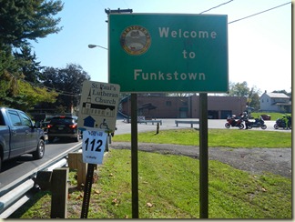
Funkstown, MD was the next stop. I overshot this location by a bit, and had to do a U-turn to get back to the parking lot where my bike (and others) are parked.
DSCN0419

The next stop was the Road Kill Café, located in Artemas, PA. The road to and from the Road Kill Café was awesome.

DSCN0421

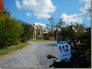
I’ve been to the Farnham Colossi earlier this year (one of my Roadside America trips), so I knew what to expect. I didn’t expect the novel route that my Garmin GPSr would suggest – I knew of the paved road adjacent to the property; what I didn’t know is the goat trail that allows a “shortcut” to get to that paved road. Helpfully, the Garmin maps showed the speed limit as 55 mph on the goat trail, so every foot of 15 MPH to avoid shaking the bike loose on the gravel and washboard cost time against the budget. Oh well, “they” say that there’s a GS hiding under all that RT “tupperware”, so off I went. I got there safely, found the correct statue (third from the left), and got the photograph.
DSCN0424

From there, I headed south to find a historic marker on Rt 50 in Virginia. I’ve been by this spot many times over the years…this time, I got to stop, take a photograph, and snag 49(!) points.

DSCN0426

My next stop was the John Marshall’s Birthplace memorial near Midland, Virginia. I’ve been here before, too, so I knew that there was a ~1/2 mile hike to the monument that was likely to be really muddy. I’d factored in the 20 minutes I’d need for the hike the trail, take the photograph, and then hike out. There was a couple of fellow bikers hanging out on a picnic bench as I arrived – I imagine they thought it was odd that riders in ATGATT were showing up, doffing helmets and jackets, and hustling down the trail with a camera and golf towel (err, rally flag). I was happy to have them hang out on the picnic table, though, figuring that they’d keep an eye on my bike.

DSCN0428

From the John Marshall Birthplace memorial, I had a nice (but slow – “rush” hour traffic) ride to Orange, Virginia. I had misjudged the effect of Friday afternoon traffic on my schedule. I simply hemorrhaged time as I sat behind trucks and school buses on the two-lane, no-passing-zone roads in that part of Virginia.

The Orange County Airport is located just outside the historic town of Orange, Virginia. As some (not me, thankfully) visitors say, “stop for the speeding ticket, stay for the history”. The goal at the Orange County Airport was to locate a stamp, and use the stamp on my rally book. I searched both the old operations building, and the new one, and couldn’t locate the stamp. A quick call to the Rally Masters settled on a substitute – a photograph of the Orange County Airport sign.

DSCN0430

Orange is also home to one of the more popular Harley-Davidson dealers in the mid-Atlantic, Waugh Enterprises.

From Orange, I needed to head west, to the crest of Skyline Drive, in Shenandoah National Park.

This highway marker is on the eastbound side of U.S. 33, across the street from the entrance to Skyline Drive. I hadn’t scouted this location online, so when my GPSr said to find it in the park, into the park I went. I realized after looking at the GPSr closer, that the marker was outside the park. I lost a couple of minutes fumbling for my park pass and doing a few U-turns.

DSCN0432

From the Knights of the Golden Horseshoe bonus, I needed to ride to Natural Chimneys Regional Park to get a photograph of the sign at the entrance. It was getting dark, so I used my headlights to help illuminate the sign.

DSCN0434

I’ve been by the golf course at Swannoa several times (while motorcycling, not golfing), so I had a good idea what I should find at the bonus location. It was dark by this time, so I brought a flashlight, along with my camera and flag, to find the bonus location.
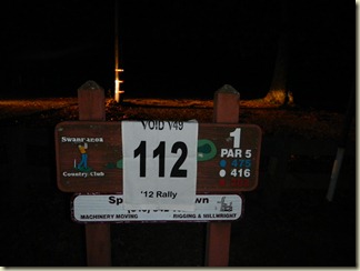
DSCN0436

There was some huge social event going on at Washington and Lee University the evening I stopped by. I imagine that the young women dressed up for some kind of party were amused with a ATGATT rider stopping by to make a quick photo stop.

DSCN0438

This is a photograph of a bikini-clad woman riding a dinosaur in Glasgow, VA. This hasn’t been on my giant critters list until now. I’ll have to come back in the daylight to get a proper picture.

DSCN0440

I’d been by the next location on my own travels – it had been a bonus location for this year’s Cape Fear Rally, but I didn’t stop for it then – I thought it was too far off the track. My GPSr said the location was right off the road. It was dark, but I couldn’t find anything like the description given in the rally pack (something like “find a gate hanging from two stone pillars”), so after thinking about the problem for a few seconds, I elected to head up a gravel road (past a sign letting me know that the area was really closed after dusk). After going up the gravel road a few hundred meters, the gate became visible in my headlights.

DSCN0442

Having taken the needed photograph, I turned around in the gravel very carefully, then continued south.

I’d lost enough time during “rush hour” in central Virginia that I dropped one of the bonus locations south of Roanoke. With that one dropped, the bonus in Roanoke was the last one before heading to Lynchburg to get a couple of hours of sleep.

Connie and I had been to Roanoke earlier in the year; while there, I wanted to snag a particular virtual geocache (I build practice rallies using virtual geocaches, normal geocaches, and roadside attractions, among other things). Imagine my surprise when I find myself back in the same spot, in downtown Roanoke, reading historical markers! There was some kind of event going on, so it was fun to find a safe place to park the bike near the marker. One of the EMTs on duty came over to ask me what all the motorcyclists were doing, jumping off their bikes, writing down numbers, then getting back on their bikes to get out of town. Pretty funny.

After Roanoke, it was time to take the mandatory rest stop. Because of my fixation on Fort Monroe, I elected to take the mandatory rest at the Rally HQ hotel in Lynchburg. During the Void in 2011, I did the odometer check just after midnight, and completed the rest bonus at the rally hotel.

I scoped out a place to start and stop the mandatory rest bonus – it was a 24-hour grocery store in Lynchburg. We were to put no more than 6 miles on the odometer from the start of the mandatory rest to the end. I thought I had a LOT more margin that I did…I nearly used up all six miles in getting from the grocery store, to the hotel, and back again.

After some nice rest, I was off again, heading south and east.

This highway marker near Pleasant Hill, NC, discussing the exploits of Lord Cornwallis, was missing the good stuff. I got a picture of what was left, then went off in search of a receipt. By this time, I was a little short on fuel, as well, so I was hunting for a fuel station.

DSCN0443

This nearby place was happy to sell me a candy bar, but couldn’t produce a computer generated receipt with all the right information, so I snapped a picture, then went off in search of fuel.

DSCN0445

My next stop was to visit a historical marker to retrieve some dates (one of the other themes of this year’s Void was math, so there were several bonus locations that involved numbers).

My next stop was the Ruritan Memorial in Sunbury, NC.

DSCN0447

I visited the Fort Monroe National Monument to get a stamp for my rally book (28 points!) and for my National Parks stamp book (which I carry in the tank bag). Fort Monroe really turned out to be a bad idea – I got caught in the usual traffic jam on I-64, and there was just too much riding and not enough bonus stopping. Oh, well.

So, after getting out of the I-64 traffic, I was headed back to Lynchburg. I knew I was going to be in the penalty window, but that I could get enough points at the next bonus to pay the incremental penalty and give me enough time to complete the scoring packet before the next penalty increment kicked in.

This would have been a lot better, were it a chicken…had to settle for a nice dairy cow, though.

DSCN0448

Scoring.

I made it back to Lynchburg a few minutes after the penalty window started, but the elevated cow offset the first penalty increment. I got my stuff off the bike, scribbled the last bit of data necessary to get the scoring packet complete, then checked in to stop the clock.

I did okay at the scoring table, leaving no points on the table (which is really good).

Banquet.

The banquet was first-rate (as is usual for the Void Rally). I got a lot of time to chat with my friends, before I headed back to my room to get a nice night’s sleep.

The journey home.

We’d had spectacular weather for the rally – reasonably clear skies, with very pleasant early October temperatures. That was not to hold, though. The rain started sometime overnight, so the area was pretty damp when I got up on Sunday morning.

I waited for the weather to clear a bit – I’m usually either nearly the last or the last out of the parking lot to head back for the barn. Today was no exception. It was a bit chilly and damp, but it was still a nice ride home.

I can hardly wait for the 2013 rally season to begin!